找回密码
 立即注册
搜索
查看: 458|回复: 18

[值得关注] 墨西哥以南热带风暴“克丽丝蒂”(12E.Kristy) - 持续西行,数值支持发展

[复制链接]

7

主题

5

回帖

597

积分

热带低压-GW

积分
597
发表于 2024-10-21 08:40 | 显示全部楼层 |阅读模式
本帖最后由 理可的呆萌呆毛 于 2024-10-22 21:12 编辑
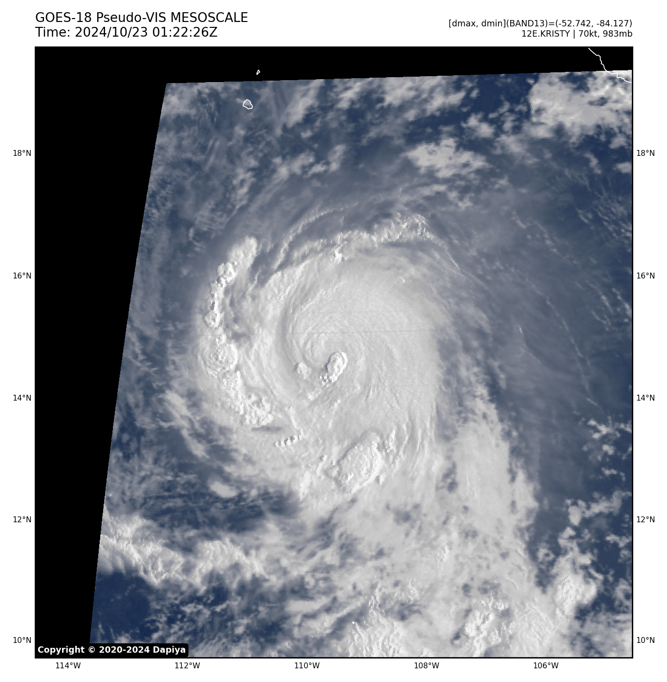
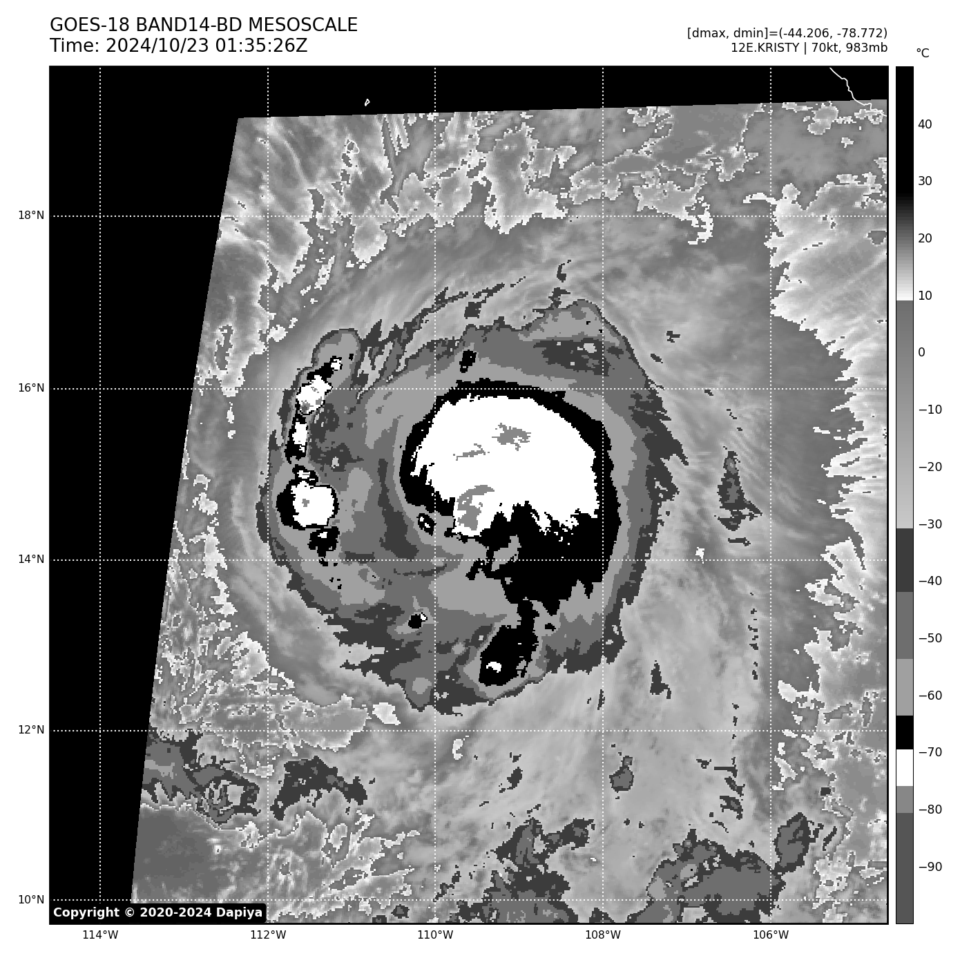
实时云图


编扰资讯

EP, 90, 2024102100,   , BEST,   0, 150N,  972W,  25, 1007, DB,


1. South of Southwestern Mexico:
A trough of low pressure over the Gulf of Tehuantepec is producing
disorganized showers and thunderstorms. Environmental conditions are
conducive for further development, and a tropical depression is
likely to form within the next couple of days, while the system
moves westward at around 15 mph away from the coast of Mexico.
* Formation chance through 48 hours...high...70 percent.
* Formation chance through 7 days...high...90 percent.


本帖子中包含更多资源

您需要 登录 才可以下载或查看,没有账号?立即注册

×

评分

参与人数 1金钱 +3 威望 +3 收起 理由
红豆棒冰冰 + 3 + 3 90E

查看全部评分

8

主题

1500

回帖

3243

积分

台风

Super Typhoon

积分
3243
发表于 2024-10-21 10:35 | 显示全部楼层


WTPN21 PHNC 210200
MSGID/GENADMIN/JOINT TYPHOON WRNCEN PEARL HARBOR HI//
SUBJ/TROPICAL CYCLONE FORMATION ALERT (INVEST 90E)//
RMKS/
1. FORMATION OF A SIGNIFICANT TROPICAL CYCLONE IS POSSIBLE WITHIN
180 NM EITHER SIDE OF A LINE FROM 15.1N 96.3W TO 14.0N 102.5W
WITHIN THE NEXT 12 TO 24 HOURS. AVAILABLE DATA DOES NOT JUSTIFY
ISSUANCE OF NUMBERED TROPICAL CYCLONE WARNINGS AT THIS TIME.
WINDS IN THE AREA ARE ESTIMATED TO BE 23 TO 28 KNOTS. METSAT
IMAGERY AT 210130Z INDICATES THAT A CIRCULATION CENTER IS LOCATED
NEAR 15.0N 97.2W. THE SYSTEM IS MOVING WEST-SOUTHWESTWARD AT 23
KNOTS.
2. REMARKS: AN AREA OF CONVECTION (INVEST 90E) IS LOCATED NEAR 15.0N
97.2W, APPROXIMATELY 50NM SOUUTH OF PUNTA ESCONDIDA, MEXICO. ENHANCED
INFRARED SATELLITE IMAGERY AND A 210033Z SSMIS 91GHZ SATELLITE IMAGERY
DEPICTS A STRENGTHENING CIRCULATION, WITH PERSISTENT CONVECTION, AND
CURVED DEEP CONVECTIVE BANDING BUILDING OVER THE CENTER. ENVIRONMENTAL
ANALYSIS REVEALS THAT INVEST 90E IS IN A FAVORABLE ENVIRONMENT FOR
DEVELOPMENT WITH WARM (28-29C) SEA SURFACE TEMPERATURES, GOOD POLEWARD
OUTFLOW ALOFT, AND LOW (10-15KTS) VERTICAL WIND SHEAR. GLOBAL MODELS ARE
IN GOOD AGREEMENT THAT INVEST 90E SHOULD GENERALLY TRACK WESTWARD OVER
THE NEXT 24-48 HOURS . MAXIMUM SUSTAINED SURFACE WINDS ARE ESTIMATED AT
23 TO 28 KNOTS.,MINIMUM SEA LEVEL PRESSURE IS ESTIMATED TO BE NEAR 1007
MB. THE,POTENTIAL FOR THE DEVELOPMENT OF A SIGNIFICANT TROPICAL CYCLONE
WITHIN THE NEXT 24 HOURS IS HIGH.
3. THIS ALERT WILL BE REISSUED, UPGRADED TO WARNING OR CANCELLED BY
220200Z.//
NNNN

本帖子中包含更多资源

您需要 登录 才可以下载或查看,没有账号?立即注册

×
P

0

主题

431

回帖

851

积分

热带风暴

积分
851
发表于 2024-10-21 11:53 | 显示全部楼层
内迪恩原先的LLCC已消散,这个是新中心,看来要用新名字了

8

主题

1500

回帖

3243

积分

台风

Super Typhoon

积分
3243
发表于 2024-10-21 13:50 | 显示全部楼层


ZCZC MIATWOEP ALL
TTAA00 KNHC DDHHMM

Tropical Weather Outlook
NWS National Hurricane Center Miami FL
1100 PM PDT Sun Oct 20 2024

For the eastern North Pacific...east of 140 degrees west longitude:

1. South of Southwestern Mexico (EP90):
Showers and thunderstorms associated with a trough of low pressure
located more than 100 miles offshore the coast of southern Mexico
have become a little better organized over the past several hours.  
Environmental conditions are favorable for additional development,
and a tropical depression or storm is expected to form within the
next day or so while the system moves westward at around 15 mph away
from the coast of Mexico.  Additional information on this system,
including gale warnings, can be found in High Seas Forecasts issued
by the National Weather Service.
* Formation chance through 48 hours...high...90 percent.
* Formation chance through 7 days...high...90 percent.


High Seas Forecasts issued by the National Weather Service
can be found under AWIPS header NFDHSFEPI, WMO header FZPN02
KWBC, and on the web at ocean.weather.gov/shtml/NFDHSFEPI.php

Forecaster Hagen

本帖子中包含更多资源

您需要 登录 才可以下载或查看,没有账号?立即注册

×
P

0

主题

6

回帖

228

积分

热带低压

积分
228
发表于 2024-10-21 14:11 | 显示全部楼层
Nadine南部的系统,算是其尾流发展而来。未来应该会逐渐吸收Nadine的残余,目前还处在低风切区域,但前方就是高风切,系统发展空间很小。

本帖子中包含更多资源

您需要 登录 才可以下载或查看,没有账号?立即注册

×

0

主题

431

回帖

851

积分

热带风暴

积分
851
发表于 2024-10-21 15:19 | 显示全部楼层
assonll 发表于 2024-10-21 14:11
Nadine南部的系统,算是其尾流发展而来。未来应该会逐渐吸收Nadine的残余,目前还处在低风切区域,但前方就 ...

类似于之前的JOHN,原中心没有出海而是消散在了陆地,在原中心西南侧的对流发展出了新中心

0

主题

6

回帖

228

积分

热带低压

积分
228
发表于 2024-10-21 16:10 | 显示全部楼层
桑美和伊欧凯 发表于 2024-10-21 15:19
类似于之前的JOHN,原中心没有出海而是消散在了陆地,在原中心西南侧的对流发展出了新中心 ...


这次不同的是,上次john中心直接消散了,然后nhc认定了新系统为john的延续。这次是Nadine的低层中心还在,两个系统暂时还并立,应该不会再看作同一系统了。

5

主题

229

回帖

1139

积分

论坛版主-副热带高压

那种勃勃生机、万物竞发的境界,犹在眼前。

积分
1139
发表于 2024-10-22 02:02 | 显示全部楼层
ZCZC MIATWOEP ALL
TTAA00 KNHC DDHHMM

Tropical Weather Outlook
NWS National Hurricane Center Miami FL
1100 AM PDT Mon Oct 21 2024

For the eastern North Pacific...east of 140 degrees west longitude:

1. South of Southwestern Mexico (EP90):
Recent satellite-derived wind data indicates that a well-defined
surface circulation is forming with an area of low pressure located
a few hundred miles offshore of the coast of southern Mexico.  
Shower and thunderstorm activity associated with this system also
continues to become better organized.  If these trends continue,
advisories will likely be initiated on this system as a tropical
depression or storm at 2 PM PDT.  This system is forecast to move
westward at around 15 mph away from the coast of Mexico. Additional
information on this system, including storm warnings, can be found
in High Seas Forecasts issued by the National Weather Service.
* Formation chance through 48 hours...high...near 100 percent.
* Formation chance through 7 days...high...near 100 percent.


High Seas Forecasts issued by the National Weather Service
can be found under AWIPS header NFDHSFEPI, WMO header FZPN02
KWBC, and on the web at ocean.weather.gov/shtml/NFDHSFEPI.php

Forecaster Delgado/Papin

本帖子中包含更多资源

您需要 登录 才可以下载或查看,没有账号?立即注册

×
~风吹过城市的角落~

5

主题

229

回帖

1139

积分

论坛版主-副热带高压

那种勃勃生机、万物竞发的境界,犹在眼前。

积分
1139
发表于 2024-10-22 02:37 | 显示全部楼层
本帖最后由 renzhetegong 于 2024-10-22 03:22 编辑

风场扫描已支持升格

本帖子中包含更多资源

您需要 登录 才可以下载或查看,没有账号?立即注册

×
~风吹过城市的角落~

64

主题

5165

回帖

2万

积分

顶级超台

积分
21307
发表于 2024-10-22 04:44 | 显示全部楼层
本帖最后由 ygsj24 于 2024-10-22 06:35 编辑

000
WTPZ42 KNHC 212044
TCDEP2

Tropical Storm Kristy Discussion Number   1
NWS National Hurricane Center Miami FL       EP122024
300 PM CST Mon Oct 21 2024

The low pressure system located offshore the southern coast of
Mexico has quickly become better organized since last night based on
available GOES-West imagery and wind-derived satellite data. An
ASCAT wind pass from a few hours ago indicated that the surface
circulation had become well-defined and sustained winds were already
around 30-35 kt. Subjective Dvorak analysis from TAFB and SAB at 18Z
were T2.0 and T2.5, respectively. Based on these data, advisories
are initiated on Tropical Storm Kristy with an initial intensity of
35 kt.

The initial motion of this tropical storm is westward at 270/15 kt.
Kristy is expected to continue on this general motion during the
next few days as is steered by broad subtropical ridge centered well
west of Baja California. Late this week, Kristy will be approaching
a weakness created by a large cutoff low over the North Pacific.
This weakness should allow the tropical cyclone to turn to the
northwest by the end of the forecast period. The track guidance is
in good agreement, especially early in the forecast period, and the
initial forecast track follows the HCCA and TVCE models closely.

Relatively low wind shear and warm sea-surface temperatures should
allow Kristy to steadily gain strength over the next few days. The
forecast calls for the tropical cyclone to become a hurricane on
Wednesday. SHIPS guidance from both GFS and ECMWF suggest that the
wind shear values will be less than 10 kt by midweek, while the
sea-surface temperatures will be around 28-29 C. Such favorable
conditions could favor significant strengthening once the inner-core
becomes established. By Friday, Kristy will be crossing the 26 C
isotherm and the global model guidance also indicates that the wind
shear will also abruptly increase. Thus weakening is expected to
begin between forecast days 4 and 5. The NHC intensity forecast is
in good agreement with the HFIP Corrected Consensus Approach
(HCCA).


FORECAST POSITIONS AND MAX WINDS

INIT  21/2100Z 13.5N 102.0W   35 KT  40 MPH
12H  22/0600Z 13.5N 104.0W   45 KT  50 MPH
24H  22/1800Z 13.9N 107.0W   55 KT  65 MPH
36H  23/0600Z 14.1N 110.5W   65 KT  75 MPH
48H  23/1800Z 14.1N 113.9W   75 KT  85 MPH
60H  24/0600Z 14.0N 117.3W   85 KT 100 MPH
72H  24/1800Z 14.0N 120.6W   95 KT 110 MPH
96H  25/1800Z 15.7N 126.0W   95 KT 110 MPH
120H  26/1800Z 19.0N 130.2W   75 KT  85 MPH

$$
Forecaster Delgado/Papin


本帖子中包含更多资源

您需要 登录 才可以下载或查看,没有账号?立即注册

×
您需要登录后才可以回帖 登录 | 立即注册

本版积分规则

QQ|Archiver|手机版|小黑屋|TY_Board论坛

GMT+8, 2024-10-23 07:17 , Processed in 0.056168 second(s), 21 queries .

Powered by Discuz! X3.5

© 2001-2024 Discuz! Team.

快速回复 返回顶部 返回列表